 |
| Eastern half of Bristol Island appears grey in the image from 19th July 2016. SOURCE: Terra/MODIS/NASA. |
Tuesday, 19 July 2016
Bristol Island update 19/7/16
Satellite image from the 19th July 2016 shows a clear view of Bristol Island which appears to be grey in colour on the eastern half of the island. This could either be ashfall from the eruption of Mount Sourabaya or that the snow and ice has melted. An ash plume originating from Mount Sourabaya is visible drifting east-northeast. Also visible in the image are two short dark strips extending west and northwest respectively from the Mount Sourabaya area indicating lava flows.

Sunday, 17 July 2016
Bristol Island update 17/7/16
Since my last post (dated 18th June 2016) an ash plume or a plume with ash content originating from Bristol Island was visible in satellite images from various days, the most recent being on the 16th July 2016. During other days, sometimes the plume was white in colour and sometimes cloud cover prevented observations.
In my view:
a) The eruption which began during late April 2016 continues.
b) The volcano is going through a different eruptive phase consisting of continuous explosive eruptions.
c) A new eruption might be occurring although I think it's most likely one of the above two scenarios.
In my view:
a) The eruption which began during late April 2016 continues.
b) The volcano is going through a different eruptive phase consisting of continuous explosive eruptions.
c) A new eruption might be occurring although I think it's most likely one of the above two scenarios.
 |
| Ash emission on Bristol Island 16th July 2016. SOURCE: Suomi NPP/VIIRS/NASA. |
Saturday, 18 June 2016
Activity update 18/6/16: Bristol Island, Zavodovski Island
Satellite images from the 7th and 15th June shows that the eruption on Mount Sourabaya on Bristol Island persists. The ash emissions however seems to have diminished suggesting that the intensity of the eruption has reduced.
Meanwhile on Zavodovski Island a gas plume was visible in satellite images from various days since 8th June 2016.
Meanwhile on Zavodovski Island a gas plume was visible in satellite images from various days since 8th June 2016.
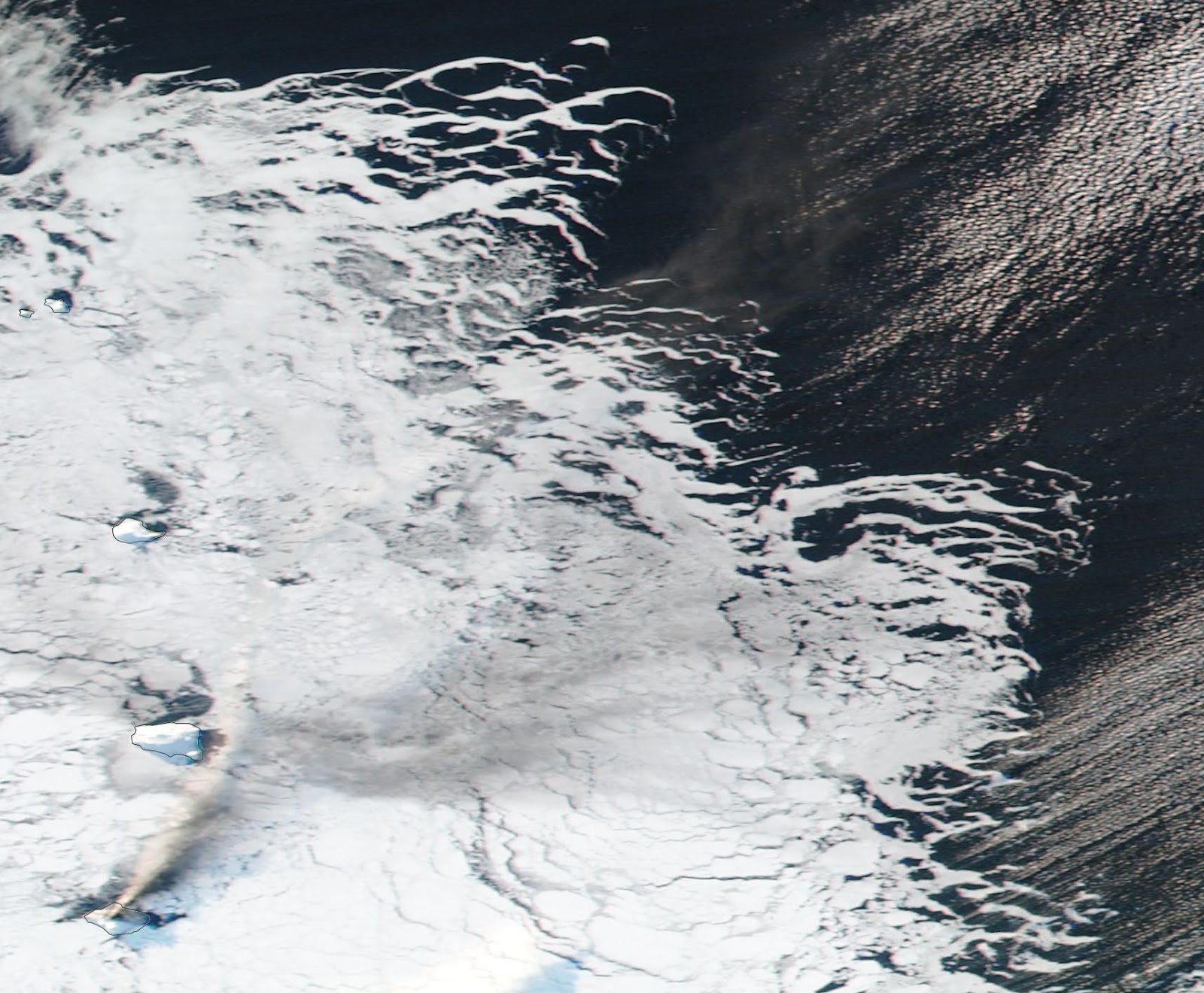 |
| Bristol Island (bottom left) continues to emit an ash plume on 7th June 2016. SOURCE: Suomi NPP/VIIRS/NASA. |
 |
| Ash emissions continue on 15th June 2016. SOURCE: Aqua/MODIS/NASA. |
 |
| Gas plume originating from Zavodovski Island on 13th June 2016. SOURCE: Terra/MODIS/NASA. |
Saturday, 4 June 2016
Bristol Island update 4/6/16
This is going to be a very quick post but the eruption continues on Bristol Island and the satellite image from 4th June 2016 clearly shows an ash plume drifting east indicating that the intensity of the eruption persists.
 |
| Ash plume drifts east on 4th June 2016. SOURCE: Suomi NPP/VIIRS/NASA. |
Thursday, 2 June 2016
Activity update 2/6/16: Bristol Island, Zavodovski Island, Saunders Island
Satellite images from the 31st May and 1st June 2016 shows that an ash plume originating from Bristol Island is clearly evident and is drifting for a considerable distance in a northeasterly direction. Bristol Island however is not the only place displaying some form of volcanic activity, Mount Curry on Zavodovski Island has been emitting a gas plume also drifting for a considerable distance in a northeasterly direction on the same days.
In an image from the 28th May 2016, a faintly dark line appears to be originating from Mount Michael on Saunders Island indicating a possible minor ash emission.
 |
| Ash plume from Bristol Island more evident plus gas emission from Zavodovski Island is present in the image from 1st June 2016. SOURCE: Aqua/MODIS/NASA. |
In an image from the 28th May 2016, a faintly dark line appears to be originating from Mount Michael on Saunders Island indicating a possible minor ash emission.
 |
| Possible ash emission on Saunders Island 28th May?. SOURCE: Terra/MODIS/NASA. |
Monday, 30 May 2016
Bristol Island update 30/5/16
Satellite image from the 26th May 2016 shows some faintly dark lines on Bristol Island suggesting the presence of lava flows and also a dark patch just west-northwest of the Mount Sourabaya area. The dark patch suggests the possibility that a new cinder cone vent may have formed or it could simply be an accumulation of lava.
Image from the 28th May 2016 shows an ash plume drifting northeast and again on the 29th May 2016 only this time it's drifting north-northeast. This could suggest that the activity may have intensified.
On the MODVOLC website a hotspot was detected during most days in May on Bristol island.
 |
| Bristol Island on 26th May 2016. SOURCE: Aqua/MODIS/NASA. |
 |
| Ash plume drifts northeast from Bristol Island on 28th May 2016. SOURCE: Terra/MODIS/NASA. |
 |
| Ash plume from Bristol Island (bottom centre-left) drifting NNE on 29th May 2016. SOURCE: Suomi NPP/VIIRS/NASA. |
 |
| Most recent hotspot detection on Bristol Island. SOURCE: MODVOLC. |
Saturday, 28 May 2016
7.2 magnitude earthquake in South Sandwich Islands
A strong magnitude 7.2 earthquake has hit the South Sandwich Islands on the 28th May 2016. The epicenter of the quake was reported to be about 58km north-northeast of Visokoi Island with a depth of 72.7km (45.2 miles).
 |
| Earthquake 28th May 2016. SOURCE: USGS. |
Subscribe to:
Posts (Atom)